Shadowwalkers: New Trinidad Map and Locations

Map[edit]

< < < Highway/Thoroughfare Map
Locations[edit]
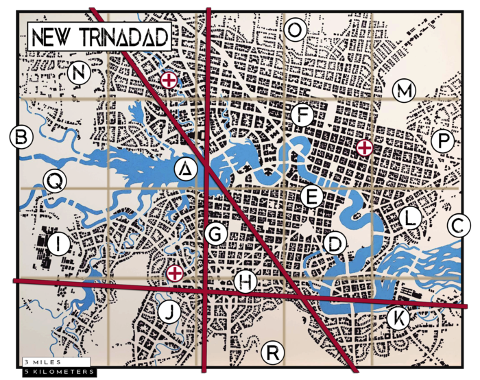
Below are descriptions of key places in and around New Trinadad (I did not spell it like the island or the college. That is intentional) as they are marked on the above map, along with a few that are not marked on the map.
Local Geotraphic Features[edit]
Some of the physical environment in and around the city.
A: Green River[edit]
Fed by several tributaries to the west, northwest, and southwest, the Green River begins it's journey in the city proper before wending away eastward.
B: Hill Country[edit]
To the west of the city the land tends to rise, ultimately becoming part of the foothills to the rocky mountains.
C: Low Country[edit]
To the east the land becomes a near endless prarie.
City Center[edit]
This isn't the hotspot for most of the city's nightlife, but it is the hub of all that goes on around it.
D: General Earl C. Douglas Park[edit]
A massive park on the Green, great for family outings, free range kids, and the occasional murder. The Motley, a mixed species collective of Changelings, make a point of patrolling the park on a nightly basis.
E: Downtown[edit]
Several miles of downtown is quaint, olde-tymey coblestone waterfront shopping and entertainment along the south bank, but radiating outward, including the north bank, skyscrapers tower over everything.
F: Governmment Center[edit]
Quaint brick and slate buildings in colonial style make up the government district and the L-shaped expanse of the New Trinadad gardens are nearby.
The Nexus[edit]
Three major leylines cut through New Trinadad, forming a triangle of concentrated energy to the west of downtown. Many small oddities can be found in this little district, but there are two structures of note.
G: New Trinadad University[edit]
To the north of the Nexus stands New Trinadad University (no association with Trinidad College in Colarado), a well respected center of learning for hundreds of years.
H: Starmap Observatory[edit]
On a hill to the southwestern end of the nexus stands a newer structure, the Starmap Observatory. Replacing a rather famous tower that no one remembers, the observatory has stood since the latter half of the twentieth century.
Places of Industry[edit]
To the south and east of the city where the land tends to get swampy, backbone industry and factories grew up like weeds. I will expand on these as needed, if needed.
I: Steel Mill[edit]
J: Meat Packing District[edit]
K: Textile Plants[edit]
L: Shipping Hub[edit]
M: Dalton Garrett Interntional Airport[edit]
Affluent Suburbs[edit]
Around the northern arc of the city. three gated communities sprung up. These also don't need much in the way of description at the outset, but might be filled in later.
N: Westgate Wings[edit]
O: Northhaven[edit]
P: Sunrise Villas[edit]
Correctional Facilities[edit]
There are pre-sentencing lockups and holding wards in all the police precincts and area hospitals including a three story county jail attached to police HQ, but there are also two post-sentencing facilities on the outskirts of New Trinadad.
Q: New Trinadad Correctional[edit]
This facility is reserved for sentenced non-federal criminals convicted in New Trinadad. No one is convicted or sentenced as a federal criminal in New Trinadad.
R: St. Augustine Asylum[edit]
An inexplicable proportion of New Trinadad's criminal element is clinically insane. This is their forever home.
Hospitals[edit]
Hospitals are each represented on the map by a red cross. Grids are numbered left to right and top to bottom 1-20.
Northside (grid 2)[edit]
Green River Memorial (grid 9)[edit]
St. Bridgette's (grid 12)[edit]
Not on the Map[edit]
Some things remain elusive, hard to pin down and label on a map, but they are there in the background marking time and holding place.
The Undercity[edit]
Beneath the city proper lies the Undercity, a loosely connected realm of sewers and tunnels and sub-basements long forgotten by the city above. A pack of wererats (not changelings but true Lycanthropes), known as the Jacksaw and led by the Rat King, rule the Undercity.
The Neverwhen Doors[edit]
Throughout the city one might suddenly come across a crooked blue door in a crooked blue frame connected to nothing, just standing in the midst of the street or in a field or under a tree. Such a door might only be seen by one in a crowd, or by many, or may only appear when the land is empty, but if opened it leads to the Ways, and the Ways lead to the Neverwhen.
The Faerie Stairs[edit]
Faerie Stairs cannot be seen without the help of one of the Fae or one of the Touched, but one mad enough or careless enough might wander up or down them without noticing and find themselves in Faerie whether they have a guide or not.
< < < Highway/Thoroughfare Map
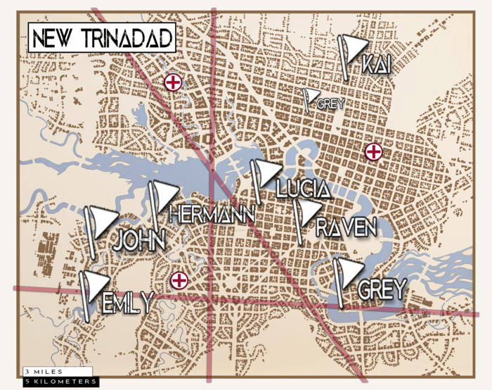
PC Map[edit]

John[edit]
- Duplex (both sides)
- F-150 (+ wife's minivan)
Konrad[edit]
- Unfinished loft over garage/tattoo parlour
- No vehicle
Lucia[edit]
- Two story House
- No vehicle
Raven[edit]
- Basement Apartment
- Yamaha YZF-R3
Grey[edit]
- Small warehouse; Bolt hole apt
- Hybrid Van, Moped
Kai[edit]
- Modest single family home; upper middle class
- Chevy Bolt. Street bike, Mtn bike, Skateboard. Urban climbing gear
Highway/Thoroughfare Map[edit]

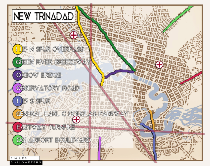
I 115 N Spur[edit]
Provides access to I 15. Elevated road all the way to the river.
Green River Breezeway[edit]
Broad surface avenue turning into a scenic bridge down by the river.
Oxbow Bridge[edit]
Limited-access span that leads to the terminus of the big boulevard.
Observatory Way[edit]
A wide boulevard that a highway spur feeds into.
I 115 S Spur[edit]
Provides access to I 15.
Earl C Douglas parkway[edit]
Scenic road that breaks off the spur and empties into the park.
Eastway Turnpike[edit]
Connects with State road 2.
Dalton Garrett International Airport Boulevard[edit]
Feeds traffic into the airport.