Shadowwalkers: New Trinidad Map and Locations

Map

Locations
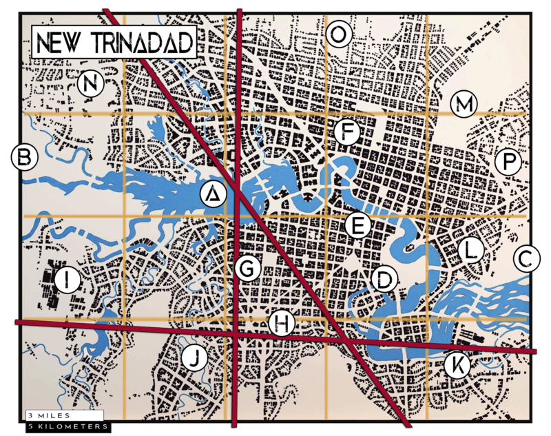
Below are descriptions of key places in and around New Trinadad (I did not spell it like the island or the college. That is intentional) as they are marked on the above map, along with a few that are not marked on the map.
Local Geotraphic Features
Some of the physical environment in and around the city.
A: Green River
Fed by several tributaries to the west, northwest, and southwest, the Green River begins it's journey in the city proper before wending away eastward.
B: Hill Country
To the west of the city the land tends to rise, ultimately becomeing part of the foothills to the rocky mountains.
C: Low Country
To the east the land becomes a near endless prarie.
City Center
This isn't the hotspot for most of the city's nightlife, but it is the hub of all that goes on around it.
D: General Earl C. Douglas Park
A massive park on the Green, great for family outings, free range kids, and the occasional murder. The Motley make a point of patrolling the park on a nightly basis.
E: Downtown
Several miles of downtown is quaint, olde-tymey coblestone waterfront shopping and entertainment along the south bank, but radiating outward, including the north bank, skyscrapers tower over everything.
F: Governmment Center
Quaint brick and slate buildings in colonial style make up the government district and the L-shaped expanse of the New Trinadad gardens are nearby.
The Nexus
Three major leylines cut through New Trinadad, forming a triangle of concentrated energy to the west of downtown. Many small oddities can be found in this little district, but there are two structures of note.
G: New Trinadad University
To the north of the Nexus stands New Trinidad University (no association with Trinidad College in Colarado), a well respected center of learning for hundreds of years.
H: Starmap Observatory
On a hill to the southwestern end of the nexus stands a newer structure, the Starmap Observatory. Replacing a rather famous tower that no one remembers, the observatory has stood since the latter half of the twentieth century.
Places of Industry
To the south and east of the city where the land tends to get swampy, backbone industry and factories grew up like weeds. I will expand on these as needed, if needed.
I: Steel Mill
J: Meat Packing District
K: Textile Plants
L: Shipping Hub
M: Dalton Garrett Interntional Airport
Affluent Subburbs
Around the northern arc of the city. three gated communities sprung up. These also don't need much in the way of description at the outset, but might be filled in later.
N: Westgate Wings
O: Northhaven
P: Sunrise Villas
Not on the Map
Some things remain elusive, hard to pin down and label on a map, but they are there in the background marking time and holding place.
The Undercity
Beneath the city proper lies the Undercity, a loosely connected realm of sewers and tunnels and subbasements long forgotten by the city above. A pack of wererats known as the Jackdaw and led by the Rat King rule the Undercity.
The Neverwhen Doors
Throughout the city one might suddenly come across a crooked blue door in a crooked blue frame connected to nothing, just standing in the midst of the street or in a field or under a tree. Such a door might only be seen by one in a crowd, or by many, or may only appear when the land is empty, but if opened it leads to the Neverwhen.
The Faerie Stairs
Faerie Stairs cannot be seen without the help of one of the Fae or one of the Touched, but one mad enough or careless enough might wander up or down them without noticing and find themselves in Faerie.